Enhance road projects with realistic visualizations

Utilize 3D visualization to help stakeholders and local communities understand the impact of road infrastructure on the surrounding environment.

Visualizations

Transforming complex road development plans into clear, compelling visuals accelerates decision-making and enhances collaboration. High-quality visualizations bridge the gap between technical details and stakeholder understanding, reducing miscommunication and streamlining approvals. By bringing designs to life, we help you identify challenges early, gain faster buy-in, and move your project forward with confidence.

360°  Photo Integration

How do you ensure your target audience understands the impact of environmental changes? By combining 360° photography with 3D visualization, we create immersive and realistic previews that seamlessly blend new designs with the existing environment. This enhances clarity, engagement, and decision-making.

Animations

Bring your project to life through motion to clearly showcase design changes, or highlight the importance of your project with the use of voice-overs.

Relevant in every phase of the project

Visualizations play a crucial role in every stage of a project, from design and participation to decision-making and implementation. Whether in 2D or 3D, they provide clear insights and enhance communication with all stakeholders, ensuring a smooth and transparent project process. By doing so, all stakeholders are on the same page throughout the duration of the project.


Map layers

Using GIS map layers with 2D design drawings in the early stages of a road project allows stakeholders to be actively involved in the design process. This approach invites them to contribute ideas and provide feedback, fostering a collaborative environment that influences the project's development. By visualizing design concepts clearly, stakeholders gain a better understanding of the project’s direction, paving the way for informed decision-making and smoother implementation.

Scenarios

Comparing different scenarios provides a clear and realistic view of how a project will change the environment. Within the 360° experience, stakeholders can seamlessly switch between current and future situations, gaining valuable insights into the actual impact of planned developments. This approach, combined with 3D visualizations, enhances understanding, fosters engagement, and supports well-informed decision-making throughout the project.

Project insight

By combining 360° photos (both ground-level and drone) with 3D integrations, road projects and their visual impact are brought to life. This approach ensures that all stakeholders share a consistent and accurate perspective, leaving no room for misinterpretation or confusion. Whether during planning, participation, decision-making, or implementation, this powerful combination enhances communication and streamlines the project process.

Roads_Engagement_Image_01

Engage your stakeholders

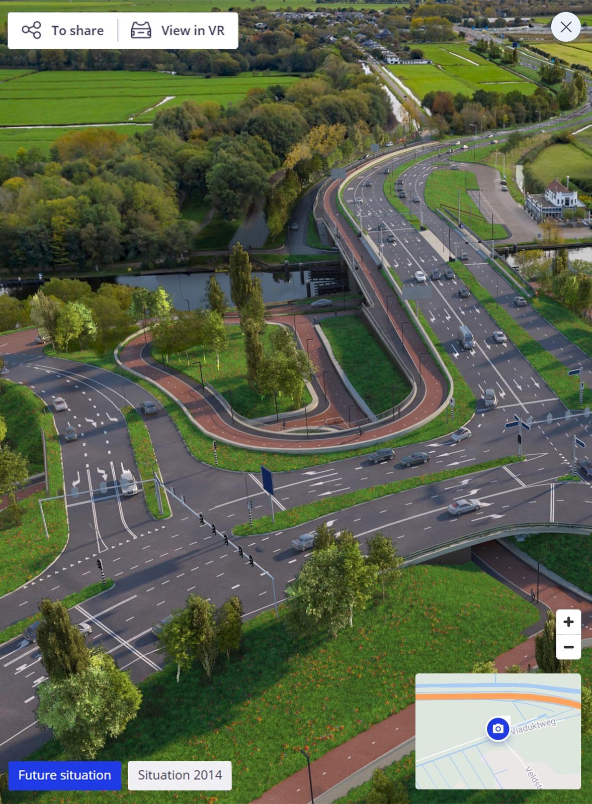
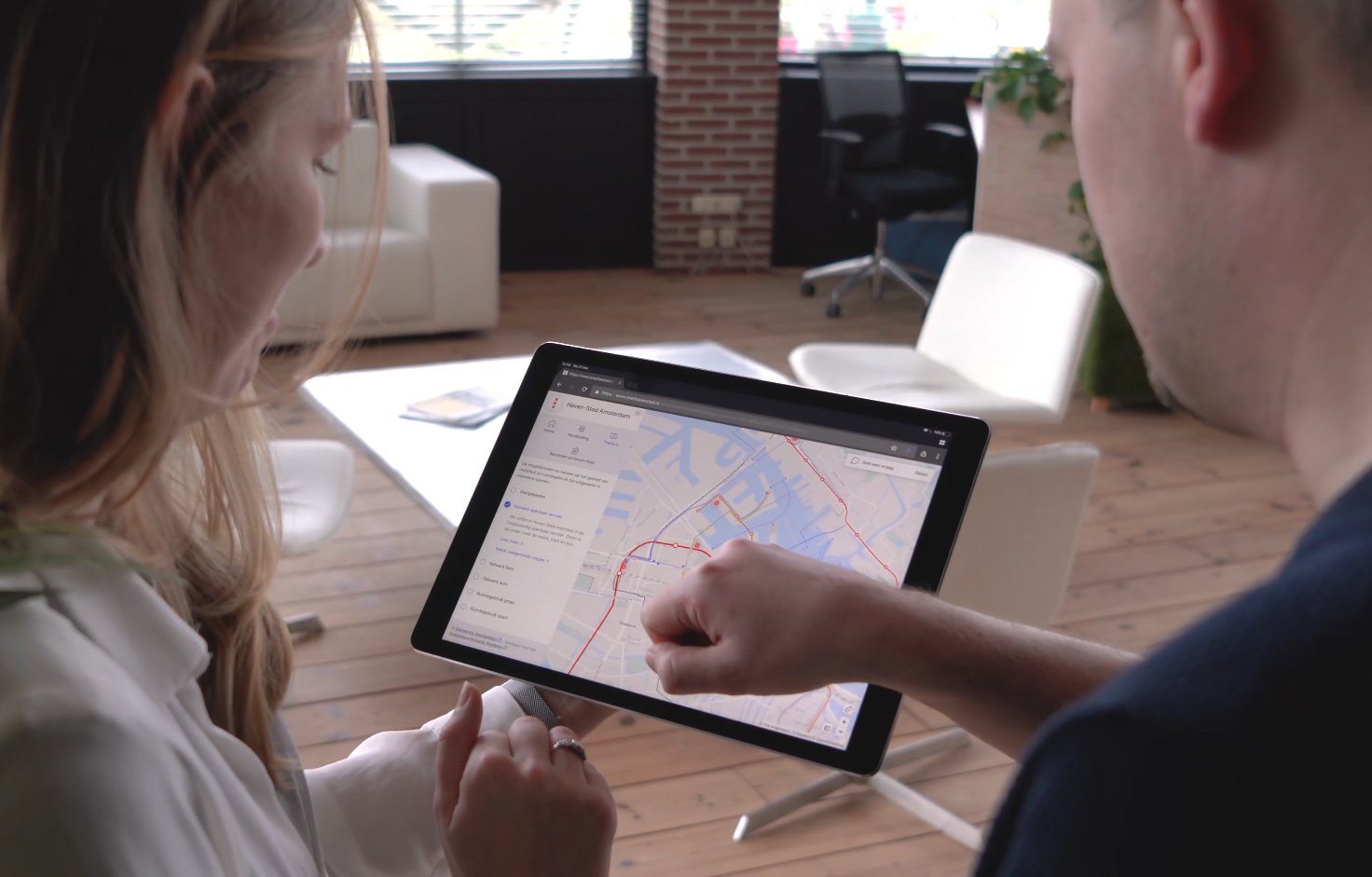
Clear communication and stakeholder involvement are key to successful project development. Our interactive platforms, Stakeholders Engagement Platform (SEP) and Virtual Consultation Room (VCR), offer innovative ways to present complex projects in an accessible and visually engaging manner. By combining 360° photography, visualizations, and interactive features, we create an immersive experience that informs, engages, and facilitates dialogue. This not only ensures transparency and better decision-making but also helps build understanding and support for your project.

Stakeholder Engagement Platform (SEP)

Our interactive web platform brings your project to life, allowing stakeholders to explore 360° environments, compare different scenarios, and make informed decisions. SEP seamlessly integrates project data, map layers, and visualizations, providing an intuitive way to navigate viewpoints. It also supports virtual reality and image-guided surveys for an even more immersive experience.

Virtual Consultation Room (VCR)

The Virtual Consultation Room transforms traditional communication into an interactive digital experience. Using 360° photography and visualizations, visitors gain a highly realistic view of planned changes in their environment. Beyond visuals, key project information, such as studies and reports. is presented in an engaging way. Integrated Q&A modules enable direct interaction with stakeholders, while 24/7 accessibility from any device ensures an open and transparent consultation process.

Areas of expertise

CAD

Precision and realism with CAD integration.

BIM

Enhanced collaboration and decision-making with 3D and BIM integration.

GIS

GIS for spatial analysis and informed decision-making in infrastructure projects.

Point cloud

Point Cloud technology for precise 3D visualization and modeling.

Photogrammetry

3D models via photogrammetry for accurate existing condition capture.

Home_Page_BannerIMG-1

Professional services

We support project organizations, architects, engineering firms, and contractors in clearly communicating complex area development plans. Our services help bring infrastructure, urban development, and water projects to life, visually and interactively.

Visualizations

We create realistic 3D visualizations tailored to infrastructure, real estate, and water-related projects. From new road designs and urban redevelopment to flood protection and water infrastructure, our visuals make future scenarios tangible and easy to understand. They are widely used for stakeholder communication, participation processes, and decision-making support.

Animations

Our animated videos convey the story behind spatial plans, illustrating changes over time, phasing of developments, or comparisons between design options. Whether it's visualizing traffic circulation, urban expansion, or the effect of climate adaptation measures, animations make complex content clear and engaging for both professionals and the public.

Support for Information Events

We provide support during information events by helping to present plans in an accessible and interactive way. This includes showcasing our Stakeholder Engagement Platform on large screens and guiding participants through the platform using VR headsets.


This allows stakeholders to explore and understand the proposed plans in an immersive and engaging manner, whether it involves infrastructure, urban development, or water-related projects.

Trusted by 400+ forward-thinking companies

We have had the privilege of collaborating on multiple Road projects with the following organizations.

logo-gemeente-amsterdam
Logo-provincie-noord-holland
PZH basislogo 2024x672 RGB 1.0
antea-group-logo-419C969479-seeklogo.com
DV-merk-merk
Van-Gelder
Heijmans_Logo.svg
rijkswaterstaat-logo
logo-provincie-gelderland
gemeente-leeuwarden-logo
Logo-provincie-Groningen

Request a quote

Need a quote? Request one now, and we’ll
reach out to you.

Online qoute

Within one working day

macbook-screen

Direct contact

Prefer to speak with us directly? Feel free to get in touch with one of our specialists!

_DSC6122-bewerkt _DSC6203-bewerkt